Baker's Crossing Conservation Area, Lebanon
Baker's Crossing Conservation Area, Lebanon
Lebanon, New Hampshire 03766
Official WebsiteBakers Crossing Conservation Area map
About this Location
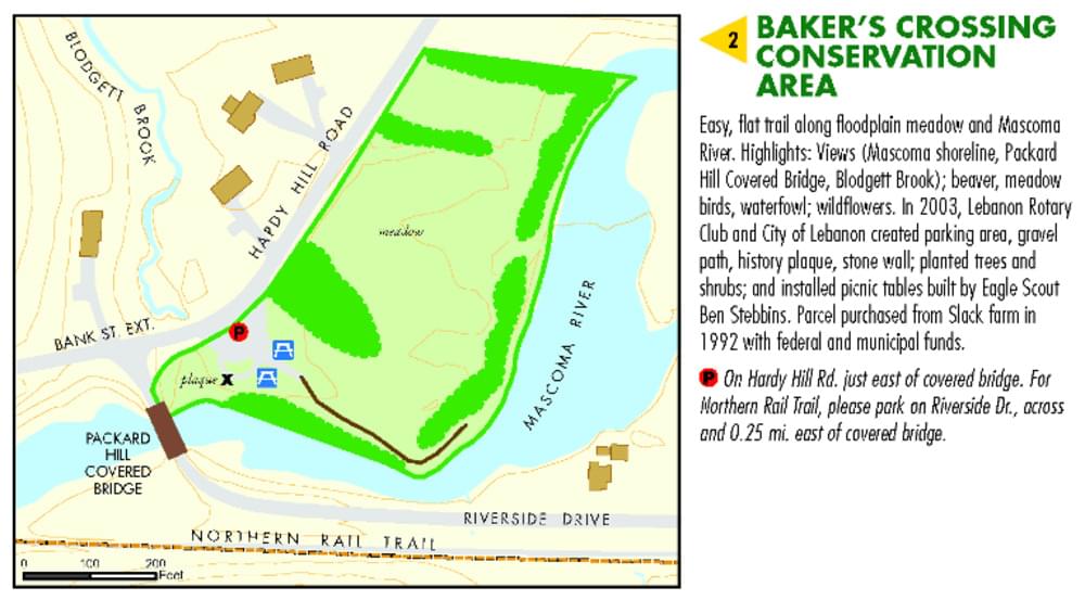
Baker's Crossing Conservation Area was purchased from the Slack family in 1992, with funding from the Lebanon Open Space Trust Fund. Historically the property had been mowed for hay, as part of a multi-generation Slack family farm. The Lebanon Rotary club actively manages the parking area, including the maintenance of planters as well as general clean-up tasks.
The scrub/shrub field as well as the floodplain forest along the river’s edge provide valuable habitat for migratory birds, butterflies, and other small animal species. The stretch of Mascoma River here provides access for fishing, noting that it is limited to fly fishing only.
The property is located in close proximity to the intersection of Hardy Hill Road and Riverside Drive, with the Packard Covered Bridge located along the southwestern boundary, and the Mascoma River along the eastern boundary. The small parking area provides access to the trailhead as well as a scenic view of the Packard Bridge and Mascoma River.
The conservation area has views of the Mascoma Shoreline, Packard Hill Covered Bridge, Blodgett Brook; beaver, meadow birds, waterfowl; wildflowers. In 2003, Lebanon Rotary Club and City of Lebanon created a parking area, a gravel path, a history plaque, and a stone wall; planted trees and shrubs; and installed picnic tables built by an Eagle Scout.
Notable Trails
Easy, flat trail along floodplain meadow and Mascoma River. Parking On Hardy Hill Rd. just east of covered bridge. For Northern Rail Trail, please park on Riverside Dr., across and 0.25 mi. east of covered bridge.
Features
Restrooms on site
Wheelchair accessible trail
Entrance fee
Content from Official Website
Last updated November 8, 2023