Mulligan Forest, Nottingham
About this Location
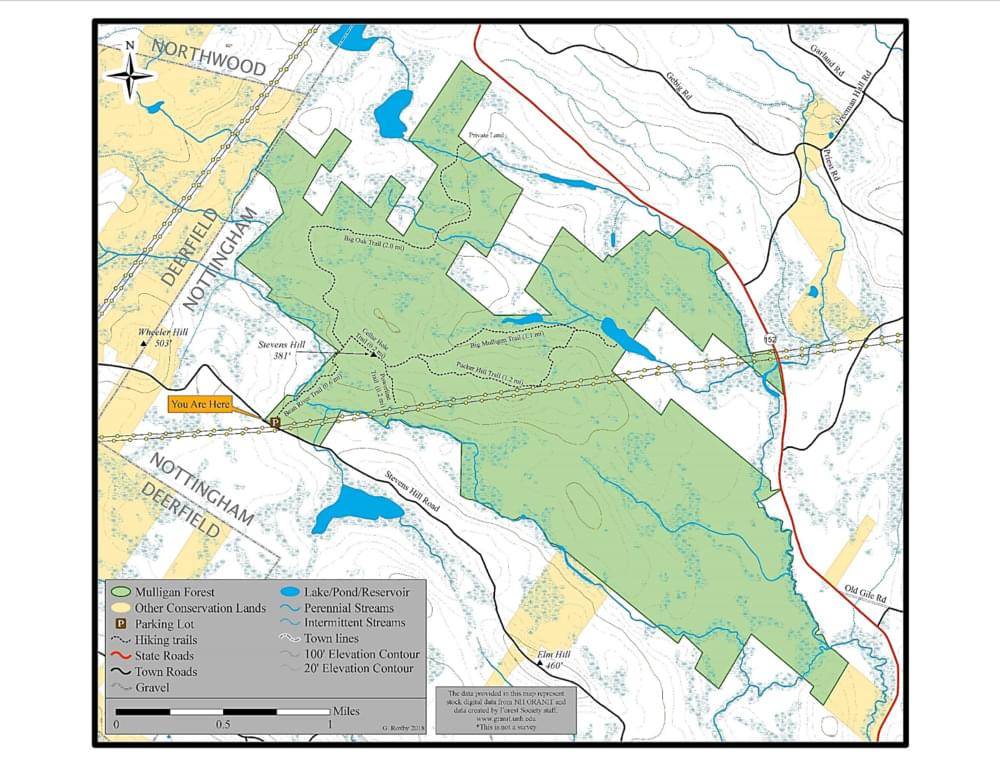
Mulligan Forest is a 2,027-acre parcel of land located between NH-152 and Stevens Hill Road. There are a few restrictions on the use of the forest: no motorized vehicles of any type, no horses, no camping, and no fires. There is one public access to Mulligan Forest on Stevens Hill Road 2.9 miles from Deerfield Road. Under the power lines, there is a small parking lot with a kiosk that contains a map of the property.
At certain times of the year, there will be timber harvests taking place on the property. At these times, certain paths may be closed to public traffic for safety purposes. Signs will be posted to alert people.
It is owned by siblings Rick and Jim Fernald and Deb Stevens. In 2007, with the generous help of the taxpayers of the Town of Nottingham, the Society for the Protection of New Hampshire Forests, and the Land and Community Heritage Investment Program, the family was able to place a conservation easement on the entire property. This means that it will never have houses or industry on it. It is open to the public for low-impact recreational and educational use.
There are lots of features of interest in Mulligan Forest. There is frontage on the North and Bean Rivers and there are two ponds, Big and Little Mulligan. There are Black Gum swamps. There are many historical features including stone walls, old cellar holes, and foundations. The area has logging roads that can be used for hiking and cross-country skiing. It is open to hunters and fishermen. While in the forest you may see turkeys and other game birds, coyotes, bobcats, deer, maybe even a bear or moose, and definitely black flies and mosquitoes in season.
A new trail has been created, with the help of the Nottingham Conservation Commission, to form a loop with some of the existing paths. It is possible that additional trails will be built in the future.
Water and Wildlife
Mulligan Forest sits amid one of southeastern New Hampshire’s last undeveloped watersheds. The land includes six miles of frontage on the North and Bean Rivers, which drain to the Lamprey River and Great Bay, and it sits over an aquifer that contributes to the Nottingham School’s drinking water supply. The proposed conservation easement would permanently protect the property’s water resources from commercial use while allowing for a possible future municipal supply for Nottingham residents.
The land’s sheer size and diversity, from wetlands to forested uplands, supports a rich variety of wildlife including wide-ranging species like bears, bobcats, and moose, whose habitat is rapidly disappearing in southeast New Hampshire. The land also has viable habitat for Blanding’s turtle, a state-threatened species that is a high priority for conservation under the New Hampshire Wildlife Action Plan.
Public Recreation
Mulligan Forest offers more than five miles of woods roads and trails for public recreation. Under the conservation easement, public pedestrian access for hiking, hunting, cross-country skiing, snowshoeing, and fishing will be guaranteed.
Mulligan Forest forms a link between Pawtuckaway State Park and New Hampshire Fish and Game’s Lamontagne Wildlife Management Area. Its protection will therefore create a 4,000-acre protected landscape in the heart of the state’s fastest-growing region.
Notable Trails
The AllTrails website has a description and map of a hike at Mulligan Forest.
Features
Restrooms on site
Wheelchair accessible trail
Entrance fee
Content from Official Website
Last updated October 25, 2023