Kettle Pond - Groton (109 acres)
Kettle Pond - Groton (109 acres)
Groton, Vermont 05046
Official WebsiteKettle Pond State Park map
Groton State Forest Official Website
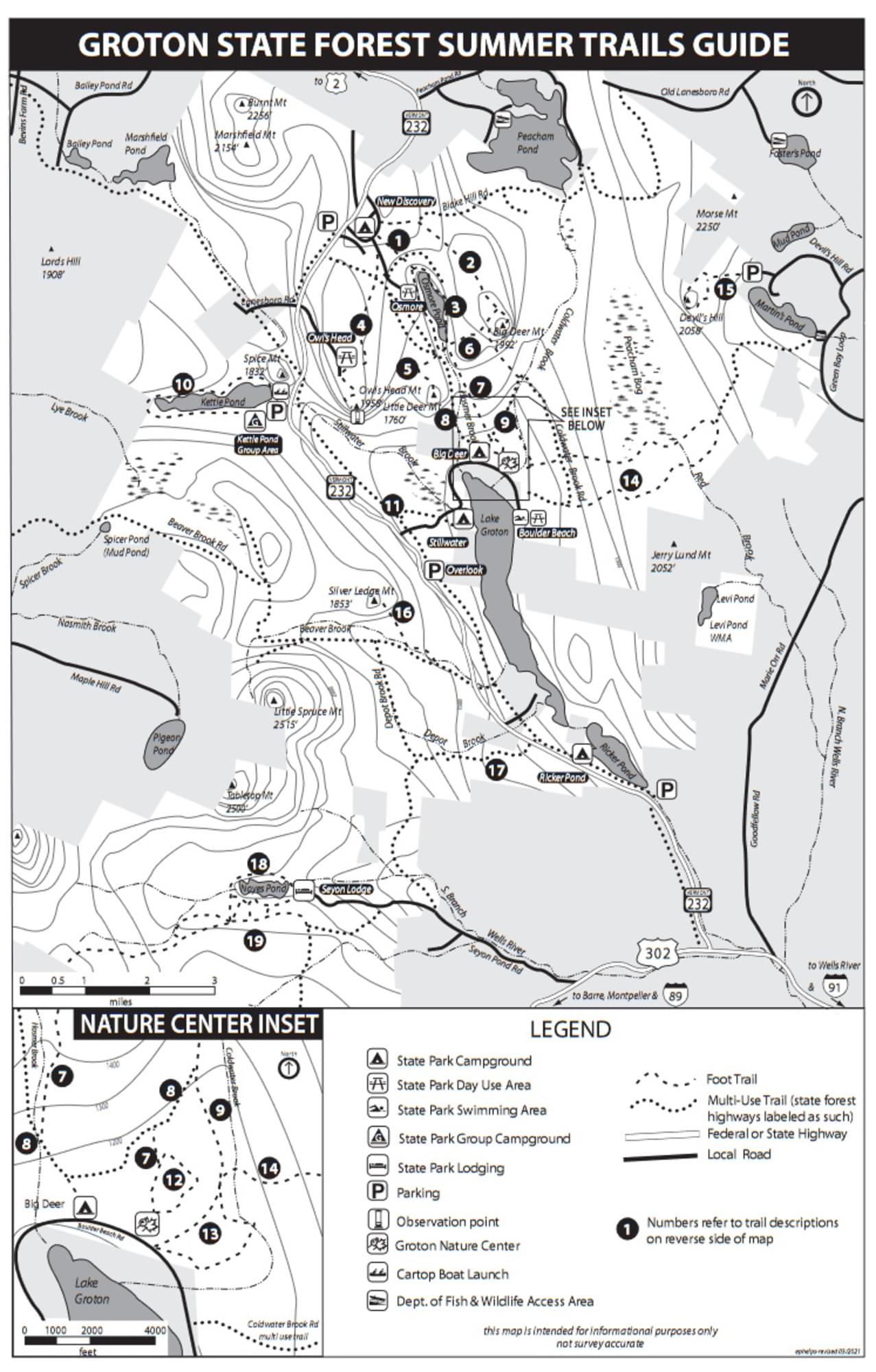
Groton State Forest Summer Trails guide and map
Tips for Birding
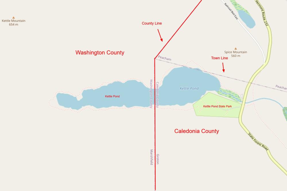
The Caledonia-Washington county line runs north to south through the middle of Kettle Pond. The Kettle Pond - Groton hotspot is located in Washington County on the west end of the pond and birds reported on checklists are assigned to Washington County. Kettle Pond State Park is located on the east end of the pond and birds reported on checklists are assigned to Caledonia County. Birders who carefully keep records of birds seen in each county should be aware of the location of the county line in this area.
About this Location
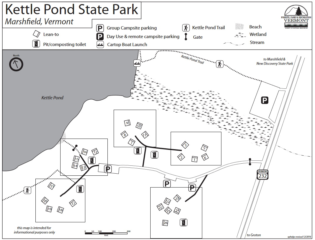
Kettle Pond is part of the Groton State Forest and Kettle Pond State Park is on the east end of the pond. Kettle Pond is an undeveloped pond, meaning that there are no buildings or roads near it. The pond is 109 acres in size and has clear water and a rocky shoreline. There are lean-to sites for group camping and remote lean-to sites for more adventurous visitors. There is also a campers' beach and a boat launch area. Kettle Pond State Park offers access to the pond and its surrounding trails. The park is open from May to October and has a fee for day use and camping.
Kettle Pond (109 acres) is a site for the Vermont LoonWatch annual survey. Birders are encouraged to volunteer as often and whenever they are able. See Join LoonWatch for details.
About Groton State Forest
See all hotspots at Groton State Forest
The acquisition of Groton State Forest began in 1919. The Forest is managed for timber resources, wildlife habitat, and recreational activities. Many rare, threatened, and endangered plants and animals occur in the Forest. The most sensitive species are associated with the cliffs, bogs and swamps, lakes, and forests around lakes.
Groton State Forest is home to seven state parks, the Groton Nature Center, and eight lakes and ponds. The area was once home to 12 sawmills and remnants are still visible. The Civilian Conservation Corps (CCC) was instrumental in developing the area, constructing roads, trails, fire lookouts, and picnic shelters, and planting trees within the forest. Glaciers covered the area 10,000 years ago and their retreat created the mountainous terrain mixed with streams, ponds, bogs, and wetlands.
Groton State Forest is also home to several state-designated natural areas, such as Peacham Bog Natural Area (748 acres) and Lords Hill Natural Area (25 acres).
Groton State Forest is open for varied and dispersed recreation, including but not limited to camping, hiking, swimming, boating, fishing, hunting, trapping, horseback riding, cross country skiing, and snowshoeing. The Montpelier and Wells River Railroad bed was converted to a multi-use trail and is part of the Cross Vermont Trail. Snowmobiling is allowed on designated VAST trails.
Notable Trails
The TrailFinder website has a description and map of a hike at Kettle Pond.
Features
Entrance fee
Restrooms on site
Wheelchair accessible trail
Content from Groton State Forest Official Website and Birdwatching in Vermont
Last updated October 11, 2023
 Map adapted from © OpenStreetMap contributors