Reading Pond - Reading (22 acres)
Reading Pond - Reading (22 acres)
Reading, Vermont 05062
Arthur Davis Wildlife Management Area guide and mapAbout this Location
Reading Pond lies within the Arthur Davis Wildlife Management Area.
Reading Pond (22 acres) is a site for the Vermont LoonWatch annual survey. Birders are encouraged to volunteer as often and whenever they are able. See Join LoonWatch for details.
About Arthur Davis Wildlife Management Area
See all hotspots at Arthur Davis Wildlife Management Area
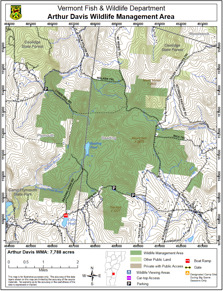
Arthur Davis Wildlife Management Area (WMA) is a 7,788-acre parcel owned by the State of Vermont and managed by the Vermont Fish & Wildlife Department. It is located in south-central Vermont, in the towns of Reading and Plymouth. Southern access is via Tyson Road, Reading Pond Road, or North Puckerbrush Road. From the east, it is accessible off Brown Schoolhouse Road, from the west by Lynds Hill Road, and from the north by Hale Hollow Road.
This WMA has common boundaries with Coolidge State Forest and Camp Plymouth State Park. Coolidge State Forest also shares a boundary with the Plymsbury WMA. In combination, these four parcels create one of the largest blocks of undeveloped state-owned land in southern Vermont. Timber rights on the WMA are privately owned and the area is actively logged. Persons using Arthur Davis WMA should be prepared to encounter current and recently logged sites, log truck traffic, and seasonally muddy roads.
Arthur Davis WMA is located within the Southern Green Mountains biophysical region. Elevations range from approximately 1,280 feet along Broad Brook at the northwest corner, to 2,602 feet on Mount Moses in the northeast corner. Mount Tom reaches a height of 2,478 feet in the eastern portion of the WMA.
Arthur Davis WMA is completely forested. Primary tree species include sugar and red maple, yellow birch, and beech. Red spruce and white pine are lightly mixed throughout the property. Stands of beech provide hard mast for black bears, which are present throughout the year. Past timber harvesting operations have provided optimum habitat for snowshoe hare and white-tailed deer.
Several small streams, ponds, vernal pools, the 22-acre Reading Pond, and a number of beaver-created wetlands are part of the WMA. State-owned Colby Pond, a 25-acre impoundment, nearly abuts the southern portion of the WMA. Both ponds and several of the beaver flowages are stopover sites for migrating waterfowl. Numerous apple trees are scattered around the old abandoned homesteads. Department personnel, in cooperation with volunteers, have been maintaining some of these old orchards for the benefit of wildlife.
A rare plant, Nuttall’s Waterweed, (Elodea nuttallii), has been found in Colby Pond.
Features
Restrooms on site
Wheelchair accessible trail
Entrance fee
Content from Arthur Davis Wildlife Management Area guide and map
Last updated October 8, 2023